This post has nothing to do with microbiology, but everything with my love for maps. It is about the former Hetch Hetchy Railroad.
Hetch Hetchy reservoir is the main source of drinking water for the city of San Francisco and other parts of the Bay Area. The densely populated SF Bay Area only gets rainfall in the winter months and is dependent on reservoirs in the Sierra Nevada mountains for the collection and storage of rain and melting snow water for the dry summer months.
The Hetch Hetchy area once was a glacier-formed valley of what is now Yosemite National Park, California. It is located in the Northwestern part of the national park, far away from the much more famous Yosemite Valley. Hetch Hetchy Valley was equally beautiful, but it was turned into a reservoir, an artificial lake, in 1923 upon the completion of the O’Shaughnessy Dam.
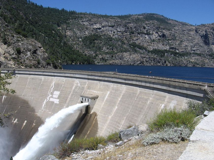
O’Shaughnessy Dam at Hetch Hetchy reservoir. Photo by Inklein at English Wikipedia, CC BY-SA 3.0, https://commons.wikimedia.org/w/index.php?curid=8256821
Here are two photos comparing Hetch Hetchy valley before and after the dam was completed, taken from roughly the same position.
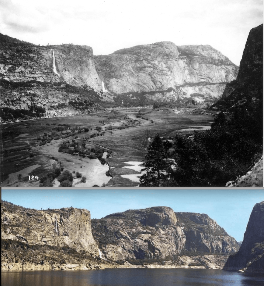
Top: Hetch Hetchy Valley in the early 1900, with the Tuolumne River. Source: – Sierra Club Bulletin, Vol. VI. No. 4, January, 1908, pg. 211 (Wikipedia). Bottom: Hetch Hetchy reservoir, May 2002. Photo by Daniel Mayer. Source: Wikipedia.
As of today, the Hetch Hetchy Project consists of the reservoir, the dam, hydroelectric plants, and a long aqueduct that carries the water to the SF Bay Area through a long series of tunnels, using only gravity.
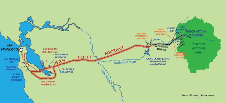
Hetch Hetchy Project. Source: By Shannon1 using Adobe Illustrator CS5; aqueduct path data from USGS topos, CC BY-SA 4.0, https://commons.wikimedia.org/w/index.php?curid=26434757.
The story about the Hetch Hetchy Railroad, built in the 1910s and 1920s to bring the construction crews and materials needed to build the dam, hydroelectric plants, and aqueducts is very interesting if you like history and maps. After completion of the dam in 1923, the HHRR was used to carry tourists and mail to the Northern Yosemite area. However, the steep terrain, sharp curves, and heavy snowfall made it very hard and expensive to operate the railroad. During World War II, HHRR rail materials such as steel and wood were used for war operations, and the railroad was finally completely dismantled in 1949.
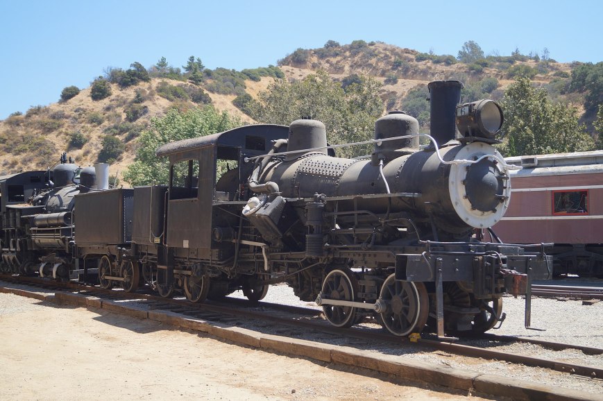
Hetch Hetchy Railroad Locomotive #2 in the Travel Town Museum in Los Angeles, 2017. Photo by NearEMPTiness, Wikipedia.com
Friends of us who live near an area where the railroad used to run told us about the success and decline of the railroad, and pointed us towards some sections where you can still see remnants of how the tracks ran. Even though the rails and wooden cross-ties are now all gone, you can still see the flattened track at some sections. Close to the Hetch Hetchy reservoir, the road to access the lake now runs over the railroad track.
Online maps and photos of the Hetch Hetchy Railroad
Hearing about the now-gone railroad got me interested in mapping the complete course of the railroad. I first searched online and found a couple of railroad and other sites that mentioned it.
- GhostRails and AbandonedRails (very similar sites) both have a rough map of the first part of the route and some discussion on where to see remnants of the railway
- San Francisco’s Municipal Transportation Agency has a site that remembers how San Franciscans could take the railway up to the Hetch Hetchy reservoir to visit the site where their drinking water came from and see their tax dollars at work.
- MTB project has a bike route that follows part of the track around Groveland
- Wikipedia has a page that describes when the railroad was in operation and which locomotives ran over it. It also describes how steep and curvy the track was.
- Latitude.to has the GPS coordinates of the start of the track, in California’s Central Valley west of the Don Pedro Reservoir, at Hetch Hetchy Junction
- There is also a Hetch Hetchy Railroad museum in El Portal, west of Yosemite National Park’s entrance on Highway 140
- Several old maps were also available online, such as this map at Yosemite News. On the map below, you can see that it split off from the (still-existing) Sierra Railroad.
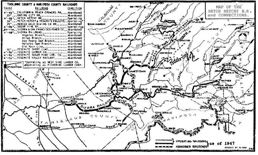
Map from 1947 displaying the Hetch Hetchy Railroad
More maps and information about the HH Railroad
The information I found online was not enough detailed to know how the HHRR exactly ran. Luckily, our friends lent us their copy of the book Yosemite’s Hetch Hetchy Railroad by Ted Wurm. The author was part of a group of railfans who traveled the railroad around 1937 and took lots of photos. This book has a map of the railroad route, and several descriptions that allowed me to start to map the exact position of the tracks.
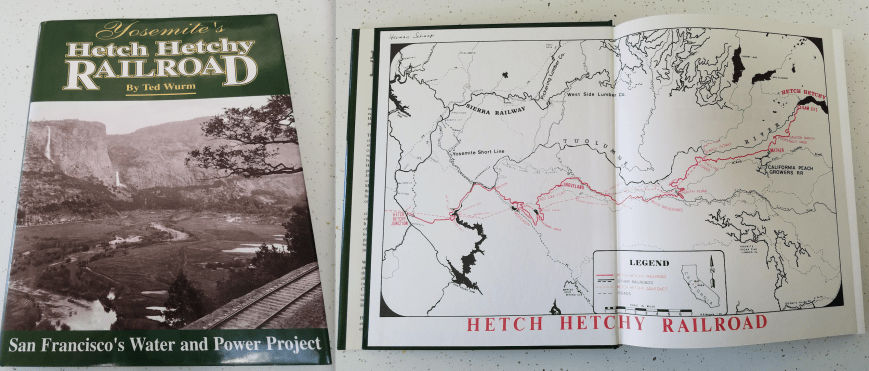
Yosemite’s Hetch Hetchy Railroad by Ted Wurm
The Groveland Yosemite Gateway Museum also has a small exhibition on the Hetch Hetchy Railroad. It consists of several photos and a topographical map in which a person called Bill Dagg draw the course of the railroad by hand.
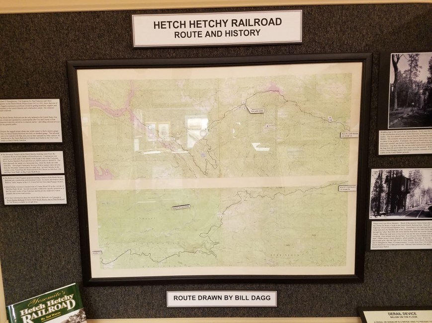
Map of the HHRR in the Groveland Museum, hand-drawn by Bill Dagg
Drawing the exact location of the railroad in Google Earth
These two maps by Ted Wurm and Bill Dagg were a lot more detailed than what I could find online. I was very excited to see how much work these two men had put into mapping the railroad.
Since I could not find an electronic version of the railroad’s course online, I decided to make a KML file myself. KML stands for “Keyhole Markup Language“, and is a way to visualize geographic data in – for example – Google Earth. Google Earth is the advanced version of Google Maps and it allows you to add extra layers. An easy way to make a KML file is to draw a line or a polygon on top of the map displayed in Google Earth.
In order to draw the map, I downloaded Google Earth Pro. There is also a Google Earth Web version that runs in Chrome and that can display KML files, but it did not allow me to make one or edit points.
Using Google Earth satellite views and the maps from Ted Wurm’s book and Bill Dagg’s map from the Groveland Museum it was easy to spot some parts of the now-dismantled railroad. In some places, the railroad is now an unpaved or paved road, while in other spots the old foundations are still visible in the landscape.
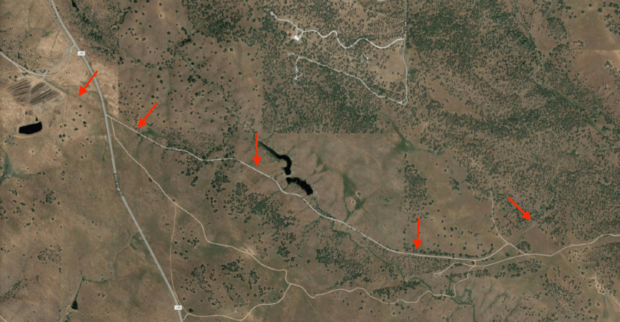
Google Maps satellite view of the western-most part of the Hetch Hetchy Railroad. The leftmost and rightmost arrows show visible remnants of the track foundations, while the other arrows show parts that now serve as a road.
I was also very excited to find some historical topographical maps on the website of the USGS from around 1947, just before the railroad was removed. These maps are available as KMZ (zipped KML) files, so you can just overlay them in Google Earth. This allowed me to draw the railroad even more precisely.
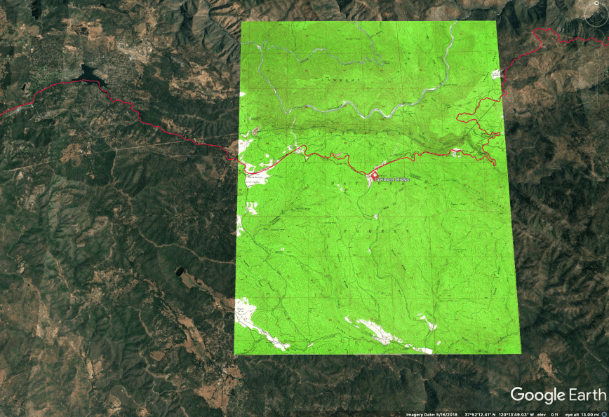
Historical topographic map from USGS as a KMZ overlay in Google Earth. The red line is my drawing of the railroad.
This was a fun project to do in Google Earth. In some cases, the historic topographical maps were a bit shifted from the current Google map, and in other cases new roads were put over the historic railroad, so I had to make an educated guess where the tracks had been. But in most spots it was easy to see the old tracks from the satellite images.
Download the Hetch Hetchy Railroad
So here it is, a link to the historic Hetch Hetchy Railroad route (KML file) as drawn by me in Google Earth. If you click on the link it will show you the route in Google Maps.
Or, if you want to edit, download the KMZ file to display in Google Earth. Enjoy!
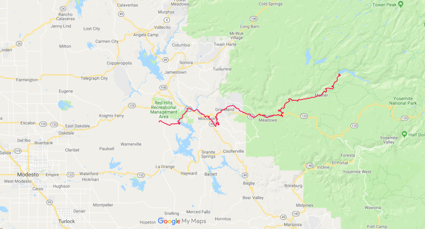
The Hetch Hetchy Railroad, mapped by Elisabeth Bik
One thing that struck me as amazing is how beautiful the incline of the trail is over certain areas. Look at this elevation profile that Google Earth draw over the complete 68-mile route. In several places, the tracks go up or down a nearly perfect 4 degrees. What a great piece of 1920s engineering that was!
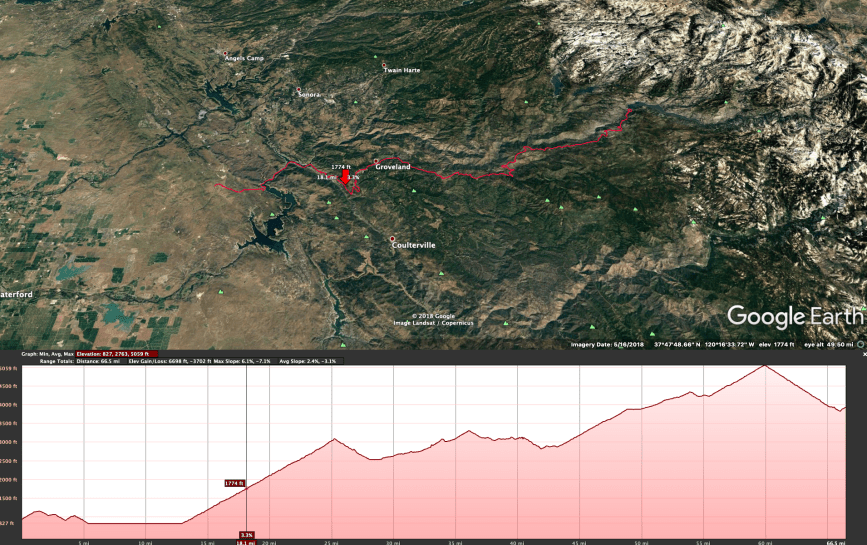
Elevation profile of the Hetch Hetchy Railroad, generated by Google Earth.

Excellant article. It fills in a lot of the gaps that I had wondered about! Great job!!!!!
LikeLiked by 2 people
Glad you liked it!
LikeLiked by 1 person
Great Job! I also like maps and am finishing up on an android app that maps red yellow and green dots along trails, roads, or flight paths to show signal strengths along these routes. Our Groveland Thursday morning hiking group has used your railroad map to explore some of the old railroad grades. I have manually made KML file maps from my app data from some of our hikes, that I would like to be automatic, to make it easier to share. It might be fun to compare notes about this. Also, I have an acquaintance that had a microbiome transplant, and said he was doing better because of it.
Keep up the good work!
LikeLike
The Groveland Yosemite Gateway Museum in Groveland. CA, whose map you show in this article, recently doubled the size of its Hetch Hetchy exhibit. That map is now shown as one continuous map with the three previous segments end-to-end instead of in separate parts. Many more photos and artifacts have been added especially about the role Groveland played as Mountain Division Headquarters for the project. Stop in and visit!
Website: grovelandmuseum.org
LikeLike
Nicce blog thanks for posting
LikeLike